GALLERY B
HIGHS AND LOWS
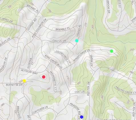
The highest elevation in Long Branch is probably under the parking lot fence at the Long Branch pool at 360 ft. The lowest is probably at the blue dot on Tabard at 280 ft. Another low is the green dot near the end of Windflower and additional high places are the yellow dot on Burnetta and the blue dot on Meadow Rue.
Looking East from the high point at the pool, if there were no trees or structures the next equal height hill would be inside the beltway.
LITTLE PROBLEM IN LONG BRANCH
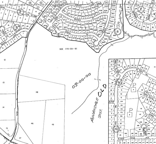
Developers had a problem. The Southern part of Long Branch was bisected by a stream. What happened to the stream except for that visible in Long Branch Falls Park. Plat map also explains why Windflower is so long.
Developers had a problem. The Southern part of Long Branch was bisected by a stream. What happened to the stream except for that visible in Long Branch Falls Park. Plat map also explains why Windflower is so long.
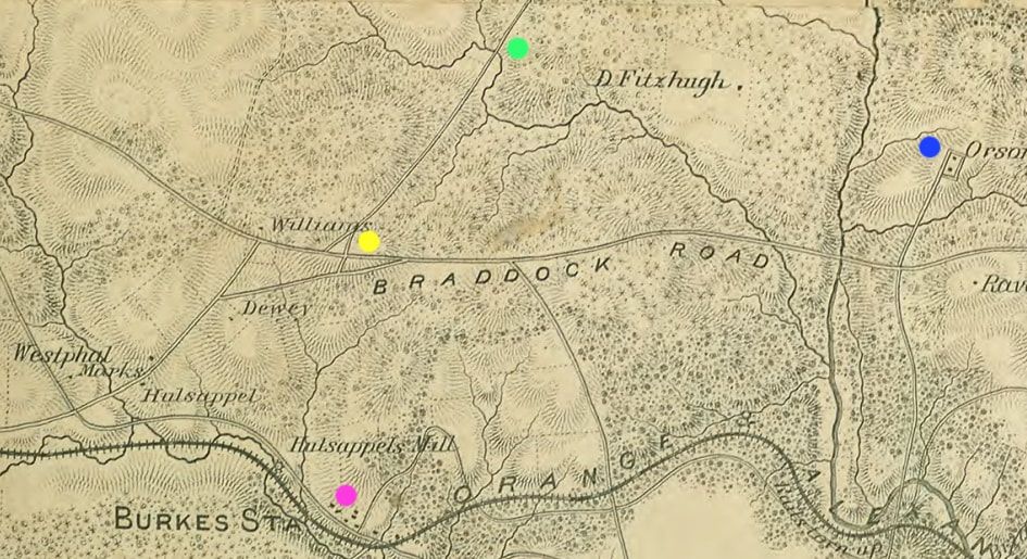
1862 CIVIL WAR McDOWELL MAP - LONG BRANCH, ETC.
Map making was tough, but critical during the first years of the civil war. Most likely the yellow dot is near the corner of Guinea Rd. and Braddock Rd. Long Branch as a bunch of trees owned by Fitzhugh. The green dot is Guinea Road crossing Long Branch Stream. The purple dot was Burke and the blue dot was Ossian Hall - a plantation house built in 1804. The dot by "D. Fitzhugh" is the Oak Hill plantation house built in 1790 which still exists in 2018. Do not expect absolute accuracy - all is relative.
HISTORY, MYSTERY, SLAVES, UNKNOWNS
As previously noted Long Branch is in a area designated as D. Fitzhugh. Would take a lot of research to determine "which" Fitzhugh this is, but... William "The Immigrant" Fitzhugh immigrated to America in 1670 and among his holdings was 22,966 acres in our part of Fairfax County. It is assumed, based on this map, Long Branch was part of one of the last pieces of this tract owned by a Fitzhugh. More research is welcomed. Of course the Fitzhughs were closely intertwined with George Washington and Robert. E. Lee. Just look up "Ravensworth" to further explore this. Of course the Fitzhughs were significant slave holders and apparently many of there slaves were buried at the corner of Guinea Road and Little River. Welcome some more research here. Many unknowns.
As previously noted Long Branch is in a area designated as D. Fitzhugh. Would take a lot of research to determine "which" Fitzhugh this is, but... William "The Immigrant" Fitzhugh immigrated to America in 1670 and among his holdings was 22,966 acres in our part of Fairfax County. It is assumed, based on this map, Long Branch was part of one of the last pieces of this tract owned by a Fitzhugh. More research is welcomed. Of course the Fitzhughs were closely intertwined with George Washington and Robert. E. Lee. Just look up "Ravensworth" to further explore this. Of course the Fitzhughs were significant slave holders and apparently many of there slaves were buried at the corner of Guinea Road and Little River. Welcome some more research here. Many unknowns.
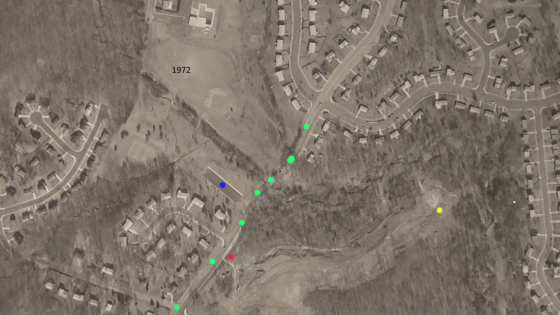
1972 NE KING SOLOMON MYSTERIES
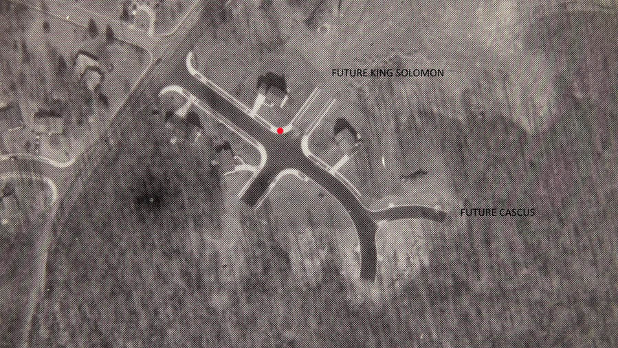
The green dots follow Guinea Road. Braddock Road would be below the picture. The lowest green dot is the intersection of El James, Guinea Road and King Solomon. Barely seen is the sidewalk to King David. The blue dot is the Rutherford parking lot. The "cut" is King Solomon being graded toward Tabard, but there are strange things. The red dot is near a road that no longer exists exiting to Guinea Road. Why? Where? The yellow dot is approximately the intersection of King Solomon and Tabard - but what are the marks going toward the creek and what is the "squiggy something" that seem to run along the north side of the future King Solomon? Answers awaited!
The green dots follow Guinea Road. Braddock Road would be below the picture. The lowest green dot is the intersection of El James, Guinea Road and King Solomon. Barely seen is the sidewalk to King David. The blue dot is the Rutherford parking lot. The "cut" is King Solomon being graded toward Tabard, but there are strange things. The red dot is near a road that no longer exists exiting to Guinea Road. Why? Where? The yellow dot is approximately the intersection of King Solomon and Tabard - but what are the marks going toward the creek and what is the "squiggy something" that seem to run along the north side of the future King Solomon? Answers awaited!
NO LONG BRANCH - TIS WOODS
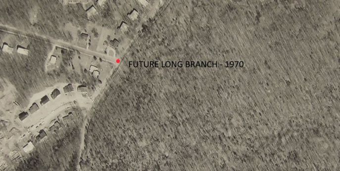
The red dot is at the corner of El James and Guinea Road. King David and Long Branch did not exist in 1970.
The red dot is at the corner of El James and Guinea Road. King David and Long Branch did not exist in 1970.
RED LIGHT - GREEN LIGHT
Some tales never die. It told in decades past that "certain affairs" were conducted in Long Branch. Red lights and green lights were discretely used as signals of availablity. Some probably know more details.
Some tales never die. It told in decades past that "certain affairs" were conducted in Long Branch. Red lights and green lights were discretely used as signals of availablity. Some probably know more details.
1972 FIRST FOUR HOUSES IN LONG BRANCH.
Amble down King David to the intersection with King Solomon Drive. In a 1972 aerial photograph you can now see the first four houses built in Long Branch. Their addresses were 4900 King David, 4903 King David, 4900 King Solomon Drive and 4905 King David. Most likely all were model homes and you could be standing on the first Long Branch sidewalk. Note the first four houses had concrete driveways and still do in 2018.